Against the Grain
The South Dakota Most Americans Never See

Most people experience South Dakota sideways.
They cross it east to west at 75 — or more likely 85 — miles an hour, following Interstate 90 through the great catalog of Western Americana: the Corn Palace, Wall Drug, the Badlands, Mount Rushmore, the Black Hills and, in August, the thunderous migration of motorcycles bound for Sturgis.
But the Missouri River ignores that narrative.
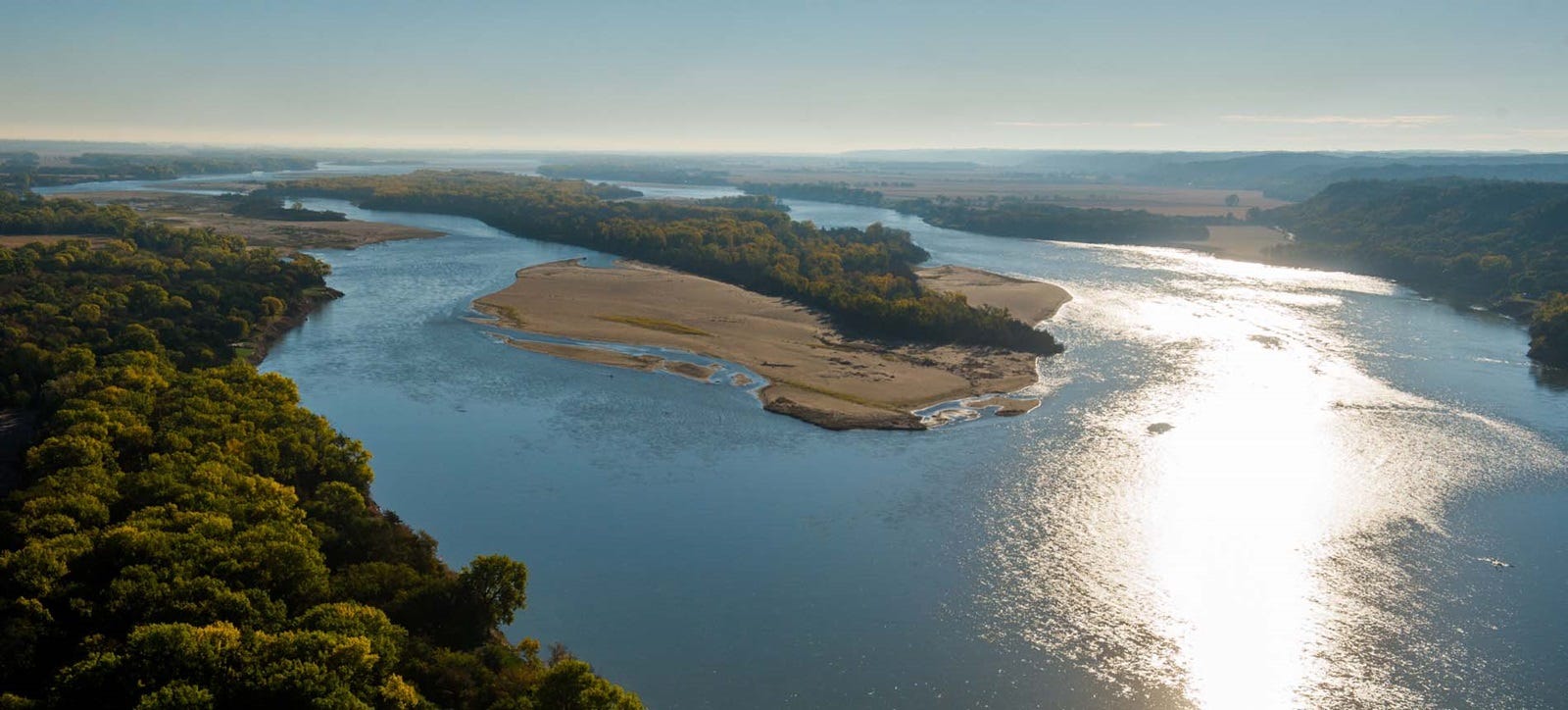
Following the river between Niobrara and Fort Pierre means traveling against the grain of both geography and expectation. Here, the Missouri flows southward through the center of the continent, carving a corridor that predates highways, state lines and even the idea of the American West itself. Along this stretch, the most compelling way to experience South Dakota is not by crossing it, but by moving upstream against the current.
And South Dakota reveals something entirely different when you travel that way.
Lewis and Clark discovered this after passing the mouth of the Niobrara, turning northward into a landscape shaped less by distant destinations than by the river itself. Along this north-south corridor, South Dakota tells quieter and deeper stories: stories of French explorers like the Vérendrye brothers and the mysterious lead plate discovered on a bluff overlooking Fort Pierre; stories of immense earthen dams that constricted the Missouri’s once-wild current, creating vast reservoirs that now define the landscape — engineering feats built for flood control, recreation and a river commerce dream that never fully arrived.
And always woven through the terrain are the enduring traces of Lewis and Clark.
South Dakota rarely dominates the national imagination. Many people struggle to define exactly what they think of the state at all. Yet that uncertainty becomes part of its appeal. Once discovered — especially along this south-to-north axis — the state reveals itself not as empty space between destinations, but as a destination in its own right.
Traveling from Niobrara to Fort Pierre is not simply a drive across prairie country. It is an invitation to see the northern plains differently: through the movement of rivers, the ambitions of explorers and the layered histories that still shape the Missouri corridor today.
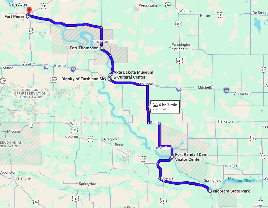
Following the Lewis and Clark Trail from Niobrara to Pierre
Niobrara State Park
Situated at the confluence of the Niobrara and Missouri rivers in northeastern Nebraska, Niobrara State Park offers camping, cabins, hiking, horseback riding, fishing, boating and wildlife viewing. Summer buffalo cookouts remain one of the park’s signature attractions. The park also serves as a gateway to the Missouri National Recreational River, one of the least-altered sections of the Missouri River and a landscape that closely resembles what the Corps of Discovery encountered in 1804.
")
Lewis and Clark camped near the mouth of the Niobrara River on Sept. 4, 1804, after strong winds broke one of the expedition’s masts. The men fashioned a replacement mast from a red cedar tree near camp. Clark described the Niobrara as “152 yards wide at the mouth” and filled with shifting sandbars. Though he considered the river unnavigable, he explored several miles upstream to a broad plain once occupied by the Ponca.
Nearby, the Missouri National Recreational River Visitor Center at Ponca State Park features interpretive exhibits, wildlife viewing areas and access to hiking trails, paddling and fishing opportunities. Visitors can also explore regional Indigenous history at the Ponca Tribe of Nebraska Museum and Cultural Center, which highlights Ponca traditions and the legacy of Chief Standing Bear. Travelers extending their stay often visit Ashfall Fossil Beds State Historical Park or Fort Niobrara National Wildlife Refuge near Valentine, known for bison, elk, waterfalls and canoe access to the Niobrara National Scenic River.
Fort Randall
Established in 1856 near the South Dakota-Nebraska border, Fort Randall became one of the Upper Missouri’s most significant military posts. The fort played a central role during decades of conflict, migration and settlement across the northern Plains. Today, visitors can walk the former parade grounds, view archaeological remains and explore the stabilized ruins of the historic chapel.

Fort Randall served as a military hub during campaigns against the Lakota and helped maintain federal presence across the region. Soldiers stationed there guarded transportation routes and monitored tensions following the Dakota conflict of 1862. Notable visitors included Buffalo Bill Cody, mountain man Jim Bridger and Gen. Philip Sheridan. Sitting Bull and members of his Hunkpapa Lakota band lived under military surveillance near the fort from 1881 to 1883. Chief Standing Bear and his brother Big Snake were also briefly imprisoned there after resisting Ponca removal efforts.
The nearby Fort Randall Dam transformed the Missouri River during the Pick-Sloan era, creating Lake Francis Case, now a major recreation destination for boating, fishing, camping and birdwatching. The Fort Randall Dam Visitor Center features exhibits on regional history, dam construction, natural history and the Missouri River ecosystem, including a freshwater aquarium displaying native fish species.
Chamberlain
Overlooking the Missouri River, Chamberlain combines Indigenous cultural interpretation, public art and outdoor recreation. The city’s most recognizable landmark is Dignity of Earth and Sky, a 50-foot stainless steel sculpture honoring the Lakota and Dakota peoples. Created by artist Dale Lamphere, the monument features a flowing star quilt design illuminated at night and symbolizes resilience, strength and cultural continuity.

Additional interpretation is available at the Akta Lakota Museum & Cultural Center at St. Joseph’s Indian School. Opened in 1991, the museum preserves and honors Lakota culture through exhibits featuring artwork, historical artifacts, regalia and interactive displays. The collection continues to grow through donations and acquisitions connected to Lakota history and traditions.

Fort Pierre
Fort Pierre marks one of the most consequential diplomatic encounters of the Lewis and Clark Expedition. Near the mouth of the Bad River in September 1804, the Corps of Discovery met the Lakota, known to the expedition as the Teton Sioux. Misunderstandings over trade and diplomacy escalated into a tense confrontation that nearly ended the expedition before Chief Black Buffalo intervened and restored calm. Today, interpretive sites at Fischers Lilly Park commemorate the encounter.

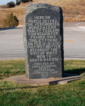
The region also preserves traces of earlier European exploration. The Verendrye Monument honors French explorers François and Louis-Joseph Verendrye, who reached the area in 1743 and buried a lead plate claiming the region for France. The original plate, discovered by schoolchildren in 1913, survives today in the collections of the South Dakota State Historical Society.
Fort Pierre later became a major center of the Upper Missouri fur trade through Fort Pierre Chouteau, established in 1832 by the American Fur Company. The post served as one of the largest and most important trading centers on the northern Plains before later becoming a military installation. Archaeological excavations at the site uncovered artifacts illustrating the close economic and cultural relationships between Native peoples and Euro-American traders.
Modern Fort Pierre also celebrates ranching culture at the Casey Tibbs South Dakota Rodeo Center, while nearby grasslands and riverfront areas offer fishing, boating, hunting and scenic drives.
Pierre
As South Dakota’s capital city, Pierre combines state history, Indigenous heritage and Missouri River recreation. The South Dakota State Historical Society Museum features exhibits on Lakota, Dakota and Nakota history, frontier settlement, archaeology and state development. Galleries also explore railroad expansion, the Great Depression and Cold War missile installations across the Plains.
LaFramboise Island Nature Area preserves an important Missouri River landscape recorded in the Lewis and Clark journals. The expedition referred to the island as “Good Humored Island”. Today, the island supports wildlife habitat, walking trails and birdwatching opportunities.
Pierre’s South Dakota State Capitol, completed in 1910, showcases marble interiors, murals and historic legislative chambers. Nearby, the Trail of Governors features life-sized bronze statues placed throughout downtown. Outdoor recreation remains central to the region, with boating, camping, prairie hiking and river access making Pierre an important stop along the Lewis and Clark National Historic Trail.
Completing the Journey
Driving Time: 4 Hours
Driving Distance: 235 Miles
When to go: Lewis and Clark were here on the outbound voyage in mid to late September. South Dakota is a tourist economy, and it will be easier to get reservations and more reasonable pricing in shoulder seasons.
Things to Note:
South of Niobrara State Park is Ashfall Fossil Beds State Park – a unique experience
Many Nebraska State Parks have great lodging options
Dignity of Earth and Sky is one of the most spectacular sites along the Trail.
Likewise, the Akta Lakota Museum is stunning in its exhibits and setting.
Fort Thompson Mounds and Big Bend are on tribal land. Check locally for the opportunity to take a tour.
Check out the Native American National and State Scenic Byway
Stop at the Log Cabin Fort Pierre visitor center and have a conversation with Sunny Hannum
Seasonal attractions can be closed even in peak season – best to check websites before planning
Along the river are a variety of water activities, walking trails, and options to get out of the car
Number of days: 1 day of driving, especially if you spend the first night near Yankton or Niobrara and the last night in Pierre or Fort Pierre allowing you to spend more time in those cities with multiple attractions
Continue your exploration by visiting the links below—and let them guide you from curiosity to connection with one of America’s most consequential chapters.
Lewis and Clark Trail News - our bi-weekly newsletter with Trail Happenings
Lewis and Clark Mobile App - take the Trail with you on your mobile device
Lewis & Clark Trail Alliance - learn about the work of the Alliance
Events along the Trail - our calendar of events you may wish to attend
Join The Alliance - Get involved
We are grateful for the generous support of our corporate and travel partners whose sponsorship helps make this work possible. When planning your travels along the Lewis and Clark Trail, we encourage you to support the businesses and organizations that invest in preserving and sharing these stories—your patronage helps sustain both the trail and the experiences that bring its history to life.